Ever wonder how your groundwater modeling consultant estimated recharge? Or why an assumed fraction of average annual precipitation was uniformly applied everywhere? What happens with runoff in ephemeral drainages? Why is the recharge estimate so important?
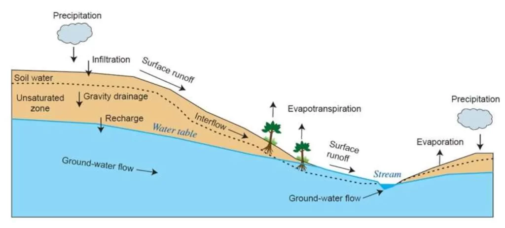
Surface water and groundwater are intimately interconnected. Water is exchanged in both directions. Recharge is strongly influenced by shallow depths to groundwater to the extent that the infiltration may be rejected. Evapotranspiration may offset the contribution of infiltrated water. Groundwater discharge to streams is a strong function of the head in the aquifer. Likewise, stream loss to groundwater is influenced by the depth of groundwater below the stream bottom and the depth of water in the stream. The water balance associated with these processes is transient and perturbed by each precipitation or snow melt event. Standalone groundwater or surface water models cannot fully simulate and illuminate the exchange between surface water and groundwater. Simulating the full hydrologic cycle and comparing model streamflows to observed streamflows is key to obtaining good estimates of groundwater recharge and constraining the groundwater model properties of hydraulic conductivity and storage.

A common groundwater modeling approach is to assume that some fixed percentage of average annual precipitation in a given area will percolate through the ground uniformly across the site, and recharge groundwater at a rate that is constant with time. This overly simplistic approach can lead to poor model representation of subsurface properties and unreliable conclusions about surface water and groundwater.
There are a host of factors influencing groundwater recharge, which varies significantly in space and time at all scales. Some examples are buildings and paved surfaces, which block recharge and modify runoff, and soil types, which affect infiltration directly and influence vegetative cover, a factor in evapotranspiration rates. These examples only represent a few of the reasons for spatial variations in the recharge rate across a site. Errors associated with the assumption of spatial uniformity are compounded by the assumption of time constancy. Temporal differences in weather generate variable runoff, as well as significant transient differences in groundwater recharge rates.
Erroneous conclusions about surface water and groundwater may lead to costly mistakes and project setbacks. Potential scenarios include poor consumptive use management, faulty stormwater and flood engineering design, unforeseen excavation and mine water management problems, and economic and ecologic consequences. Impacts to wetlands cannot be properly evaluated with a conventional groundwater model, nor forecasting and planning for effects of weather extremes and long-term climate change.
Use of integrated hydrologic modeling can avoid erroneous conclusions, reduce uncertainty, and provide useful results for long-term planning. Integrated hydrologic modeling is a powerful means to constrain recharge estimates for groundwater models and to understand and quantify the interactions between surface water and groundwater. The trend toward integrated hydrologic modeling is propelled by engineering and water management challenges such as water budgeting, well permitting, land development, and cumulative impact assessments that must consider complex issues such as ecological flow needs under both drought and high-flow conditions. Integrated models are necessary for determining aquifer sustainability and drought sensitivity, and delineating environmentally-sensitive groundwater recharge areas. Integrated models can provide the analytical tools to address complex water management challenges and evaluate contaminant migration pathways.
Some scenarios that would benefit from using integrated hydrologic modeling include:
- Assessing the effects of pumping groundwater basins in semi-arid to arid environments with ephemeral streams that provide most of the recharge to groundwater
- Evaluating impacts of varying rainfall and pumping on streamflows and lake levels underlain by shallow groundwater basins
- Investigating potential impacts of mining or industrial contaminants to surface water and groundwater resources

A paucity of subsurface data on the front end of evaluating a groundwater problem is another reason to use integrated hydrologic modeling. Rather than drilling indiscriminately to gather additional data, a model is constructed on the basis of the limited subsurface data, publicly available surface soil, vegetation, and climate data, and stream flows and surface water stages that are inexpensively measured. Calibration of the model leads to informed identification of subsurface data gaps for steering acquisition programs.
Integrated modeling produces far more accurate assessments and reliable projections to help you make informed engineering and management decisions. In many cases, integrated modeling delivers significant return on investment that more than justifies the incremental time and cost.
If you would like more information on integrated hydrologic modeling and its potential benefits to your project, please email David E. Hay, Ph.D., PG, Principal Scientist, dhay@trcsolutions.com.