

Users can view and interact with 3D CSMs through a traditional computer screen, holographic display, augmented/mixed/virtual reality and printed physical models. This range in presentation options allows CSMs to be utilized in a variety of settings- from court rooms to public meetings.
Transforming Data into Actionable Insights Through 3D Visualization
Digital Capabilities to Revolutionize Your Environmental Projects
Environmental projects often require gathering and interpreting large amounts of data to facilitate high stakes decision making that can greatly impact the financial cost, technical success and public perception of the project. Improved visualization capabilities allow project teams to make well informed decisions to achieve project success in less time while keeping costs down.
Assimilating historical site datasets into a digital 3D conceptual site model (3D CSM) helps bridge the gaps among consultants, clients, regulators and the public by presenting easy-to-understand visualizations of complex site processes and treatment or cleanup plans. Vivid and data-rich 3D graphics and animations convey information critical to the CSM in easy-to-understand terms and leverage years of costly site investigation work, so historical efforts are not wasted or forgotten. A 3D CSM can also serve as a 3D database and digital archive, becoming a powerful tool for institutional knowledge storage and transfer and limiting the impact of staff turnover.
Gain Peace of Mind with a Well-Designed Conceptual Site Model
A robust, high-quality 3D CSM gives project teams confidence that site conditions are well understood, supporting better decision-making that mitigates risk and generates desired outcomes. It can also accelerate project closure and reduce long-term costs by:
- Clearly depicting and uncovering correlations between contamination, distribution and hydrogeology
- Unearthing actionable insights from limited underground data
- Driving high-value collaboration sessions among experts, managers and clients
- Supporting consensus-building and collaborative problem solving
- Visually identifying data gaps/uncertainties to reduce decision risk
- Improving quality, defensibility and communication of groundwater modeling results
- Assisting with the selection and design of appropriate remedial solutions
Interactive 3D CSMs may be shared collaboratively with stakeholders, facilitating more productive stakeholder engagement activities and improving the likelihood of stakeholder buy-in of project plans. Interactive 3D CSMs allow users to:
- Share work to show how and why decisions were made
- Rotate the model around an axis, zoom, pan, create slices and conduct measurements
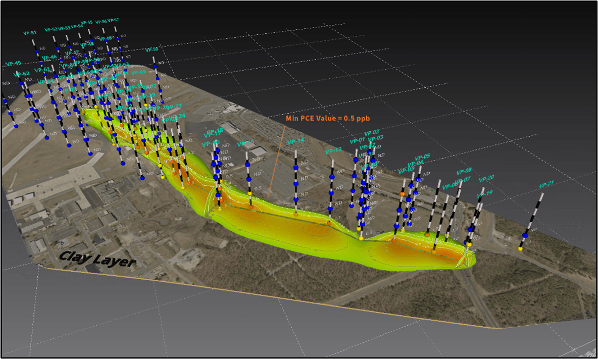
- Interrogate the model by clicking on features to reveal attributes such as borehole and well construction information, analytical results and plume volumes
Bring Your CSMs to Life with Our 3D Visualization and Analysis Toolbox
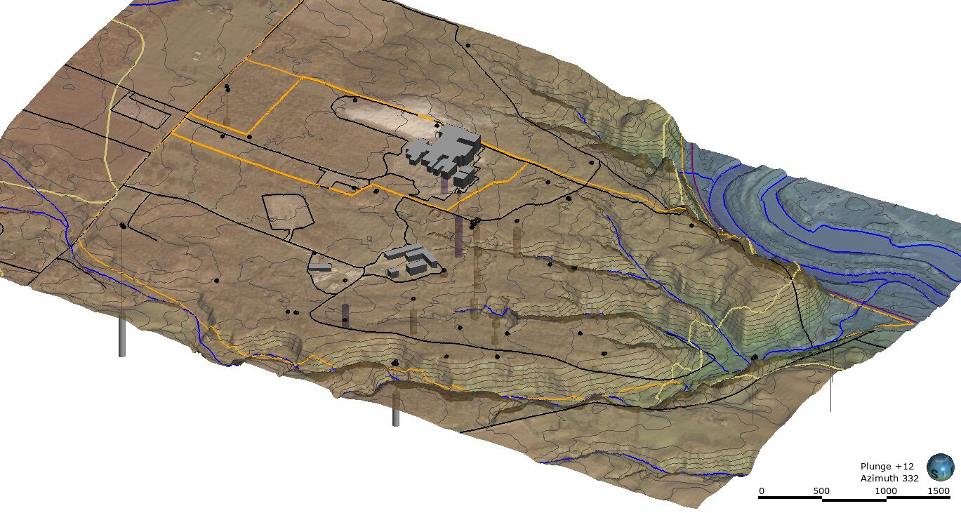
TRC uses an innovative 3D visualization and analysis (3DVA) toolbox on site investigation and remediation projects that allows teams to visually articulate complex environmental datasets in 3D to activate key decisions. The centerpiece of TRC’s 3DVA toolbox is Leapfrog Works® (Leapfrog), a galvanizing software package for advanced technical analysis and advocacy.
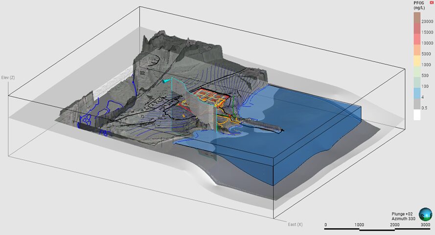
More than just pretty pictures, our 3D CSMs enable performing complex 3D quantitative analyses to answer difficult multi-factorial questions that would take much longer using traditional 2D graphical analysis. 3DVA software facilitates an interactive 3D viewing experience whereby the viewer can rotate the 3D CSM around an axis, zoom in and out to view it from any angle, create slices and interrogate the model by clicking on features linked to data tables. Our 3DVA specialists have expert-level proficiency and decades of experience with a broad range of state-of-the-science 3DVA software including Leapfrog Works®, EVS®, RockWorks® and Surfer®. The software tools we use are capable of rapidly assimilating data sets in 3D from a wide variety of sources, including:
- Topography
- Site maps and GIS/CAD layers
- Aerial photographs, LiDAR and satellite imagery
- Stratigraphic, lithologic and geophysical data
- Water, soil, sediment and air quality data
- Groundwater elevation and flow data
- Environmental Sequence Stratigraphy (ESS) data
- High-Resolution Site Characterization (HRSC) data
- Cross sections/Fence diagrams
- PDF and scanned hardcopy historical reports
- Environmental forensics data for source identification/differentiation (e.g. PFAS signature characteristics)
TRC’s value-added approach to intelligent and elegant 3DVA can be a differentiator for your projects, bringing your CSM alive in effective ways. Our 3DVA specialists are tapped into state-of-the-science visualization practices and technologies including augmented reality, machine learning/AI, scripting/automation and 3D printing.
Read About Our Technical Expertise
3D Visualization and Analysis (3DVA) allows project teams to visually articulate complex environmental datasets to activate key decisions— enabling faster, cheaper and more effective remediation compared to traditional 2D graphical analysis. Assimilation of historical site datasets into a digital 3D conceptual site model (3D CSM) helps bridge the gaps among consultants, clients, regulators and the public by presenting easy-to-understand visualizations of complex site processes and treatment or cleanup plans. TRC’s 3DVA specialists have expert-level proficiency and decades of experience with a range of state-of-the-science software including Leapfrog Works®, EVS®, RockWorks® and Surfer®.
Check out our technical resource PDF to learn more about our team of tested practitioners and the support they can provide to your organization.
Frequently Asked Questions
A digital 3D CSM is a to-scale, orthographic rendering of every component of your environmental site’s conceptual model. Unlike older « cartoon-style » CSM graphics, a digital 3D CSM is dynamic, interactive and based directly on assimilated site data. It allows project teams to visually articulate complex environmental datasets in 3D. This approach moves beyond traditional 2D graphical analysis, which can sometimes obscure the complexity of subsurface conditions. It’s like getting a detailed, interactive 3D map of your site’s geology, contamination and water flow, rather than viewing flat drawings.
A key strength of the digital 3D CSM is its ability to bridge the gaps among consultants, clients, regulators and the public by presenting easy-to-understand visualizations of complex site processes and proposed plans. This allows for high-value collaboration sessions where experts, managers, clients and regulators can discuss conditions based on a clear, shared visual understanding.
Stakeholders can often interact with the model, allowing users to rotate, zoom, pan, create slices and conduct measurements. This interactive experience allows them to see how and why decisions were made. Compelling, vivid 3D graphics and animations can be created for project deliverables, public meetings and presentations, conveying critical information effectively.
Our 3D modeling specialists are proficient in leading 3DVA software packages such as Leapfrog Works®, Earth Volumetric Studio®, RockWorks® and Surfer®. Leapfrog Works® is our centerpiece tool, known for its nimbleness, ease of use, affordability and rapid data assimilation capabilities. It employs efficient implicit geological modeling that honors all site data while allowing for easy manual adjustments. The 3D objects within the model are linked to an underlying SQL database enabling users to interrogate the model by clicking on features to reveal attributes like borehole details, well construction, analytical results or plume volumes. We also tap into state-of-the-science practices like machine learning/AI and automation to speed up development and decrease costs (e.g., by using AI-powered tools to digitize historical boring logs).
Achieve New Possibilities with TRC’s Digital 3D CSM Solutions
Our 3DVA experts leverage advanced 3D modeling tools to enhance decision-making and achieve successful project outcomes. Our solutions facilitate high-value collaboration sessions among stakeholders, presenting live 3D models to enable informed decision-making, and creating narrated animations to control the narrative and tell the winning story. TRC’s digital 3D CSM solutions are conducive to a wide range of applications, from enhancing fate and transport analyses to optimizing remedial designs to producing 3D physical models for litigation, public meetings, and conferences.

Related Materials
 3DVA / Digital 3D Conceptual Site Model Services
July 10, 2025
Partager nos perspectives
Nos praticiens partagent leurs idées et leurs points de vue sur les tendances et les défis qui façonnent le marché.

Livres blancs/rapports
Development and Types of Conceptual Site Models (CSMs)
mars 15, 2025
There are vast resources, including publications and guidance documents on the topic of Conceptual Site Models (CSMs), and the term “CSM” can mean many different things to different people depending on their technical area of expertise and their expectation about the goal or purpose of the subject CSM
Aperçus
Un modèle conceptuel de site pour les impacts de l’approvisionnement en eau des substances perfluoroalkyliques et polyfluoroalkyliques dans une collectivité résidentielle
novembre 26, 2024
Jenna Raup, Michael Eberle, Elizabeth Denly et David Glass de TRC ont récemment collaboré avec le Département de la conservation de l’environnement de l’État de New York
Aperçus
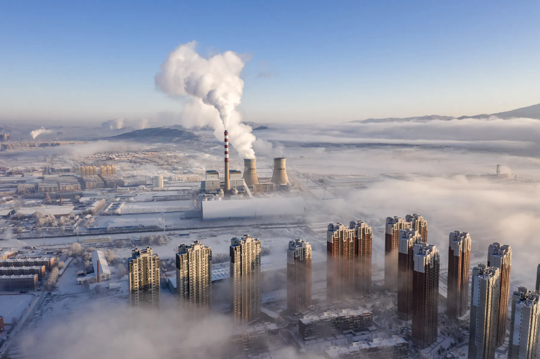
Modélisation des événements de buée et de givrage
Décembre 14, 2023
Au cours des dernières années, divers organismes à travers le pays se sont engagés à comprendre les impacts du brouillard généré par les systèmes de refroidissement. À première vue, le brouillard créé par les tours de refroidissement peut ne pas sembler être un problème important, mais il peut avoir des effets négatifs sur le public. Le brouillard peut nuire à la visibilité des personnes qui conduisent sur les routes et si les températures sont inférieures au point de congélation, le brouillard peut causer la formation de glace sur les surfaces. Pour comprendre les conséquences du brouillard créé par ces systèmes de refroidissement, les experts ont mis au point des techniques de modélisation avancées.